
Talk to us
Have questions? Reach out to us directly.
NM 14 (Cerrillos Road) Study
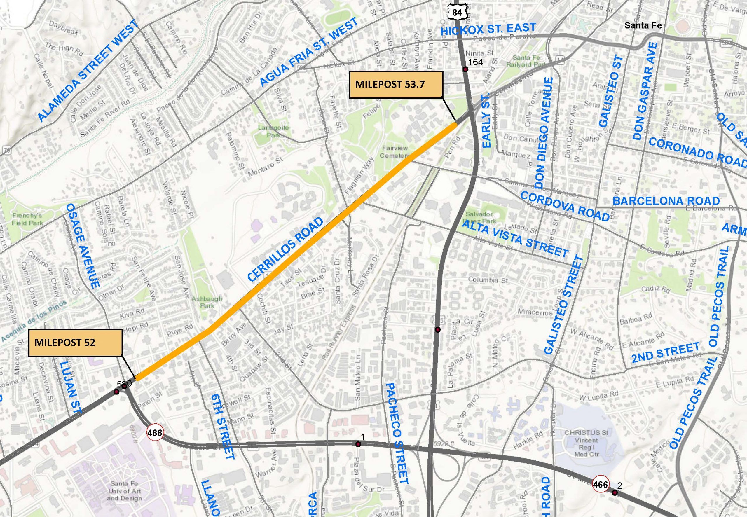
View allThe NMDOT recently completed a Phase I-A/B Alignment Study for New Mexico Highway 14 otherwise known as Cerrillos Road within the City of Santa Fe between St. Michael’s (mileposts 52.0) and St. Francis Drive (milepost 53.7).
Cerrillos Road is a major thoroughfare in the Santa Fe metropolitan area transportation system. It is one of Santa Fe’s key transportation and land use corridors and one of the City’s most heavily traveled roadways. The corridor is multimodal with diverse land uses including small retail shops, schools, and large employers. Commuter mobility and local circulation are important functions for this segment of Cerrillos Road.
The current segment of Cerrillos Road represents the fourth and final segment to be upgraded from Interstate-25 at Beckner Road to St. Francis Drive in Santa Fe. The City of Santa Fe (CoSF) and the NMDOT have executed a road exchange agreement transferring the ownership and maintenance of Cerrillos Road along the project corridor to the CoSF once construction is completed. The previous Cerrillos Road phases have already been transferred to CoSF under this agreement. Therefore, while NMDOT is leading this study and project, the CoSF has been engaged and involved throughout the process. Within the study limits, Cerrillos Road is a four-lane facility built within a uniform 80-foot right-of-way that constrains opportunities to expand traffic capacity facilities. The preferred alternative will retain four (4) traffic lanes while balancing the multi-modal uses of the corridor and minimizing the acquisition of additional right-of-way and the resulting impacts on businesses and historic properties along the route.
Purpose and Need
The study’s purpose was to identify improvements to enhance mobility for vehicular, bicycle, and pedestrian travel, address physical deficiencies of the existing transportation facilities, and to better manage traffic flow. The need was demonstrated by the following:
- People and Goods Movement: Cerrillos Road is a regionally significant roadway corridor in Santa Fe used for all types of transportation purposes. Mobility in the corridor is key to efficient people and goods movement.
- Physical Deficiencies: Based on the existing conditions analysis of the project corridor, physical deficiencies were identified for the roadway including Americans with Disabilities Act (ADA)/PROWAG compliance issues at curb ramps and driveway crossings, areas within the project limits where sidewalks do not exist, mid-block pedestrian crossing spacings, and access issues particularly for adjacent business off-street parking areas in the corridor. The existing corridor is also deficient in storm drain infrastructure.
- Multi-Modal Corridor – Transit: The Santa Fe MPO Transit Master Plan notes that Cerrillos Road is a major transit corridor. Transit utilization along Cerrillos Road accounts for approximately 33 percent of total transit service hours and well over 50 percent of internal ridership in the area. Enhancements to transit services will be investigated as part of this project.
Phase I-A Alternatives
A suite of ten (10) typical sections was developed and shared during the Phase I-A public and stakeholder meetings. Two typical sections advanced the screening efforts and were combined into two alternatives. The key variable between the alternatives was a 4-foot bike lane versus a 5-foot bike lane.
Phase I-B Alternatives and Improvements Advanced to Design
During Phase IB, the Working Group eliminated the 4-foot bike lane and No-Build alternatives resulting in a Recommended Alternative for advancement to design consisting of:
- 10- to 14-foot center medians
- 10.5-foot driving lanes
- 5-foot bike lane/roadway shoulders
- Variable 4 to 6-foot sidewalks (4-foot minimum in constrained areas).
A suite of location-specific improvements is also included in the Recommended Alternative based on feedback and concerns expressed by members of the Santa Fe community.
Image Gallery
Talk to us
Have questions? Reach out to us directly.